ESRI on-line course – Using Raster Data for Site Selection
Problem: You are a biologist that would like to model bald eagle habitats near Big Bear Lake.
Analysis Procedures: 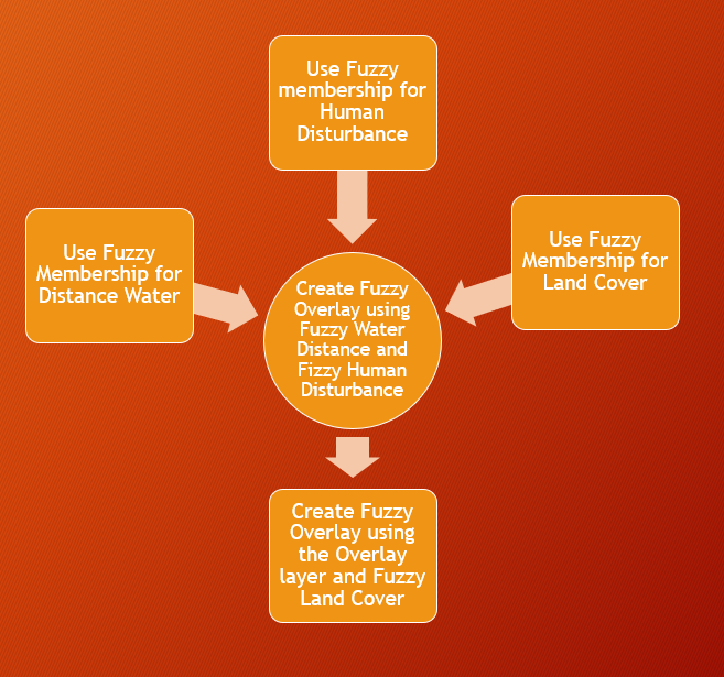
This exercise was an ESRI course and so all data Was available through ESRI. To solve this problem I created fuzzy membership layers with the corresponding characteristics for the Water, landcover, and human disturbance layers. I then used fuzzy membership to overlay the water distance and human disturbance layers. I then reran the tool with new overlay layer and the fuzzy landcover layer.
Results:
This map is a depiction of suitable habitat around Big Bear Lake for bald eagle using fuzzy overlay logic, green areas depict most suitable locations
ESRI Certificate of Completion
Application and Reflection: The skills learned in this module are essential for locating wildlife habitat. For my thesis I will actually be locating optimal habitat patches for migratory birds.
Problem Description: In a simpler problem we may be able to use fuzzy membership in combination with other site selection tools. For example, we would like to find where the most dangerous location for walker around lake Johnson Park so that the city can improve these areas or place signage
Data Needed: To solve this problem we would need to know factors such as slope, tree cover for production of leaf litter and fallen limbs, and trail type (paved, unpaved, rocky, or grassy). Factors that would need to use fuzzy logic to rank the importance of these features for repair as funds are limited and you do not have usage data for every part of the trail system. This would include distance to water and distance from parking lots
Analysis Procedures: For the first factors you could use a weighted suitability analysis. For the factors based on preference you will need to use fuzzy membership and then fuzzy overlay for all layers.
Additional Resources from ESRI:
<Go Back to Linear Referencing Go Forward to Site Suitability Analysis>